Territorial data at the service of public decision-making

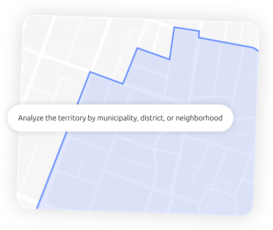
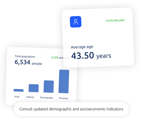
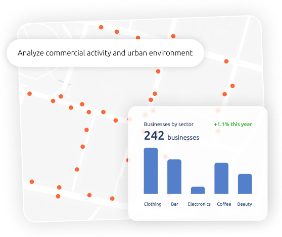
Pickgeo is the territorial intelligence platform for public administrations that enables the analysis of municipalities, neighbourhoods, and commercial areas through clear, visual data ready for decision-making.

A municipal service that boosts local commerce, entrepreneurship, and investment attraction, adapted to the reality of the Spanish territory.

A tool designed for the public sector

Town councils and local administrations already use Pickgeo to better understand their territory, support entrepreneurs and investors, and justify public decisions with objective and up-to-date data.

Territorial intelligence applied to public management

Pickgeo allows public administrations to better understand their municipality or region through the analysis of demographic, economic, commercial, and mobility data.

All in a visual, accessible platform designed for both technical and non-technical users.

Common use cases in the public sector

Pickgeo is used as a support tool for public policies, local economic development, and territorial planning.
Boost local commerce and economic activity through decisions based on territorial data
Analyze areas with higher or lower commercial dynamism to prioritize actions and investments
Identify areas with potential for entrepreneurs and investors based on demand and urban context
Support urban regeneration policies with objective analysis of the territory and its activity
Justify public actions with objective data to citizens and stakeholders
Provide territorial information to citizens and economic agents in a clear and accessible way

A complete service adapted to public administration

Pickgeo offers administrations a solution structured around two complementary components:

Pickgeo Retail internal platform

Entrepreneur and investor attraction portal

A clear, transparent process adapted to the public sector

We have designed a simple process so any administration can start using Pickgeo without technical barriers or complexity.
01

Tool demonstration

We show you how Pickgeo works and what information you can obtain for your territory.
02

Setup and training

We configure the tool according to your needs and train users for independent use.
03

Flexible use depending on needs

The platform adapts to both one-off projects and ongoing use.
04

Monitoring and improvement

We remain available to provide follow-up, resolve questions, and gather improvement proposals together with public administrations.

Better-informed public decisions

Pickgeo enables administrations to work with clear, up-to-date, and easy-to-interpret territorial data, resulting in more efficient public policies aligned with local realities.

Greater transparency in decision-making

Data helps justify public actions with clear indicators to citizens and stakeholders.

Better territorial planning

Analyze population, economic activity, and mobility to anticipate needs and balance urban development.

Real support for commerce and entrepreneurship

Identify opportunities for new businesses and provide useful information to entrepreneurs and local traders.

Optimization of public resources

Prioritize investments according to territorial impact, maximizing social return.

Objective information for citizens and economic stakeholders

Provide clear and structured data that helps people better understand the environment and make informed decisions.

Start analyzing your territory with reliable data

Discover how Pickgeo can help you better understand your municipality or region and make public decisions based on real data.

Frequently asked questions about Pickgeo for public administrations

We answer the most common questions from town councils and public entities that want to use territorial data to improve their management.

Is technical knowledge required?

No. Pickgeo is designed for both technical and non-technical staff.

Are the data updated?

Yes, the indicators are updated periodically.

Can any municipality in Spain be analyzed?

Yes, the platform is specialized in Spanish territory.

Do you offer consulting?

We do not offer strategic consulting, but we do provide training and support for using the platform.

We provide a platform that integrates your company’s data with over 2,000 geolocated variables to leverage geographic information and make the best decisions based on solid predictions.

Contact